4D Imaging Technology
4D Imaging Technology
1) Technical Principle
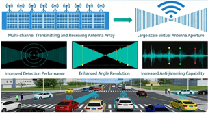
4D imaging technology uses large-scale antenna arrays and multi-channel parallel processing to simultaneously measure target range, speed, azimuth, and elevation. The radar transmits FMCW signals, and the receiver acquires high-density point cloud data. After clustering and tracking algorithms, it outputs four-dimensional information including position, speed, heading angle, and height, significantly increasing point cloud density and resolution. This achieves continuous and stable trajectory tracking, providing an all-weather, low-latency, high-precision holographic sensing data foundation for intelligent urban road networks.
2) Key Features
-
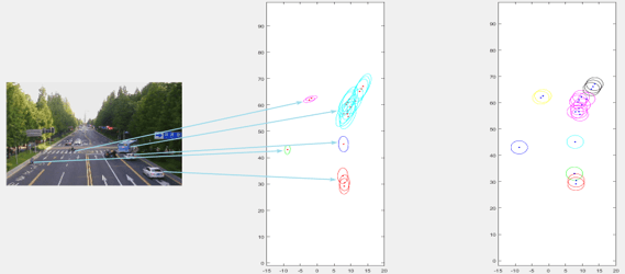
High-density point cloud output – Generates over 20,000 points per second, restoring target contour, size, and motion attitude.
-
Accurate elevation measurement – Captures target height information, enabling 3D spatial positioning of vehicles, pedestrians, and other objects.
-
Multi-dimensional high-precision sensing – Simultaneously outputs range, speed, azimuth, and height, fully characterizing target motion state.
-
Low-latency, high-precision positioning – Millisecond response, decimeter-level positioning, meeting real-time application needs such as urban signal control.
-
High adaptability in complex scenarios – High resolution and 4D perception effectively handle complex traffic scenes including parallel vehicles, curves, and weaving areas.